Rice-growing and hydraulic cultural landscape of Betafo
Date of submission : 14/11/1997 Criteria: (iii)(iv)(v)
Category : Mixed
Submitted by: Centre of Arts and Archeology of the University of Antananarivo & Ministry of Culture and Communication
Location: The region of Betafo is located in the central part of the country, called Vakinankaratra, and more precisely 25 km west of the city of Antsirabe on the road to Morondava.
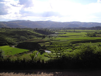
The proposed area is the countryside of the small city of Betafo characterized by an original rice-growing and hydraulic landscape and by a great beauty. It consists of a landscape composed of a rice-growing valley (I), hillsides occupied by terraced rice fields (II), and a complex hydraulic network (III), the result of a secular knowledge passed on from one generation to another, a delicate social balance, and a place where harmony between man and the environment lies.
(I) The rice-growing valley located uphill and downhill from the village of Ambohiambo fits between two chains of mountains and exploits in every detail the topography of the land while benefiting from a well-conceived irrigation system.
(II) In some areas and particularly on each side of a river with steep banks exists numerous terraced rice fields that follow the curves.
(III) The complex hydraulic network serving the valley and the hills is a witness to the domestication of water on its regulations in order to have a fair division for all the rice fields, first between the lines and then between the families. The network includes traditional water points on each dam that are loose, made of dry rocks and parallel and layered canals dug on the northern side of the gorges of the river with steep banks, a dozen parallel canals used to divert the water for the lines and small canals for the families with distributors made of volcanic rocks. These last canals can be underground passing under the rice fields when there is not enough space.
Site and Rova of Tsinjoarivo
Date of submission : 14/11/1997 Criteria: (iii)(vi)
Category : Cultural
Submitted by: Centre of Arts and Archeology of the University of Antananarivo & Min of Culture and Communication
Location: Tsinjoarivo is located 114 km south-east of Antananarivo in the region of the great oriental forest and 46 km east to the city of Ambatolampy.
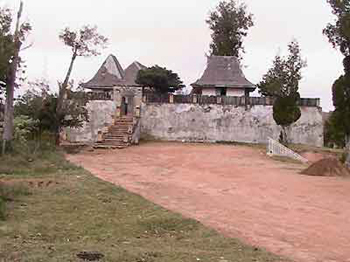
Tsinjoarivo includes a natural site of great beauty (I) and a historic place of the XIX century (II).
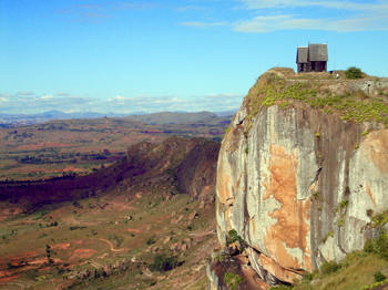
(I) Located on a peak at an altitude of 1 675 m, the site of Tsinjoarivo overlooks the vast horizon of the great forest of the East which is spread over more than 100 km up to the sea and looks down on the boiling falls of the Onive river in a big noise of water and an atmosphere of fog with shimmering rainbows.
(II) In 1834, the queen RANAVALONA I (1828-1861) decided to build on the peak the Rova (meaning a royal enclosure which includes different constructions to make into a countryside residence and a place for holidays.) Subsequently the court of the Kingdom of Madagascar stayed there many times for holidays: RANAVALONA I in 1840, 1842 and 1856; RANAVALONA II in 1880 and 1882 and RANAVALONA III in 1890. Raised on a built terrace of an height of 5 m, the Rova measures 50 m by 30 m and shelters five rustic constructions made of wood and clay: the residence of the Prime Minister, who used to accompany the queen during her trips, the house of the aide-de-camp and her ladies companion, the house sheltering the dining room and the one for the officers of the court. All of these houses have preserved pieces of furniture and objects from that period and the Ministry of Culture made it into a museum.
South-West of Madagascar, Mahafaly Country
Date of submission : 14/11/1997 Category : Mixed
Submitted by: Centre of Arts and Archeology of the University of Antananarivo & Min of Culture and Communication
Location: The Mahafaly country is located in the south-west region of Madagascar on the calcareous plateau found between the rivers Menarandra and Oni-lahy, located 150 km east and south-east of Tulear with Ampanihy, Ejeda, and Betioky as administrative centers.
The proposed area is a mixed property, at the same time natural (I) and cultural (II).
(I) The Mahafaly country, like the whole south part of Madagascar, is a rough sub-desert region with a strange vegetal landscape adapted to the drought and the heat and that seems to belong to another world: trees without leaves, forests without shadows, thorns everywhere, succulent plants of every sort, trees octopus or candle-trees with thorny candelabra and fleshless arborescent euphorbias with their caustic latex, puffy baobabs in the form of bottles; swollen pachypodium, plants that cannot be found anywhere else in the world
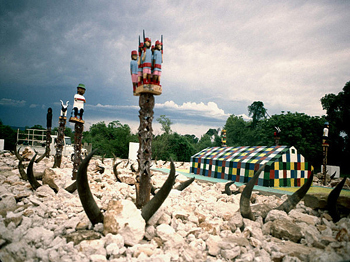
(II) Since a long time ago, the inhabitants of the south of Madagascar and particularly the Mahafaly have known to take advantage of this hostile and thorny nature of the vegetation for the defense of their villages which are built in the middle of an impenetrable belt of thorny trees. It is also in this frame that can be found a form of traditional art, particularly characteristic of Madagascar and that is also at the heart of a range of ritual practices: the Mahafaly funeral art
This funeral art is composed of tombs (big square buildings of 10 to 15 m on the side, a height from 1 m to 1,5 m, constituted of stones roughly cut on the external parts and rough stones piled up in the internal part covering the funeral compartment); standing stones raised in the middle of the main facade and at each angle of the building, octopus-trees planted against the building, on both sides of the main facade the aloalo which are wood posts sculpted with a height ranging from 1,50 m to 1,80 m and planted on the top towards the east and finally the sculls of zebus sacrificed during the funerals that can last weeks, and with some familiar objects of the deceased. The aloala include geometric sculptures with an openwork design on their trunk and sculpted figurines on the top recalling the personality of the deceased, cherished possessions, scenes from everyday life, zebus, birds
The Cliff and caves of Isandra
Date of submission : 14/11/1997 Criteria: (iii)(iv)(v)
Category : Mixed
Submitted by: Centre of Arts and Archeology of the University of Antananarivo & Ministry of Culture and Communication
Location : They can be found in the south center of Madagascar, in the Betsileo country et are located 30 km northwest of Fianarantsoa, the capital of the region.
Their national geographic coordinates are: X = 448,80 km and Y = 530,40 km
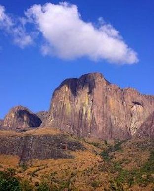
The Cliff and the caves of Isandra are at the same time a natural site (I) and a fortified archaeological site (II) that blend into the landscape of the picturesque rocks of the valley of the Isandra little river.
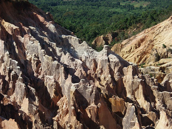
(I) As seen from the valley, an impressive vertical cliff overlooking a big slope of rocks slides integrate itself in a granite chain oriented north-south. This landscape can be explained by the differential erosion in the migmatites and the granites of the crystalline base. The forms of erosion of the big cliff are the stream fluting, the perforations in taffonis that can reach an important size (2 to 3 m in opening and in depth) and most importantly, rock falls caused by diaclase. Following successive rock falls a huge pile of granite blocks with empty interiors that can be used as shelters was created at the foot of the hill: the caves, utilized by the former inhabitants in XVII and XVIII centuries A.D.
(II) Because of the defensive possibilities offered by the particular position of the huge sections of rocks that fell from the hill, the former inhabitants have leaved there by developing an ingenious and original fortified site. They have taken advantage of the impressive chaos of granite blocks in order to organize the fortified village. They have established protective compounds between the blocks, constructed platforms of housing with a retaining structure made of dry rocks. Moreover, the natural position of the blocks has allowed the development of a great number of shelters under the rocks which the contemporary person has wrongfully called caves.
The originality of the site also lies in the maze of cavities, sometimes impressive, corresponding to the cracks between the blocks of rocks; these cavities have served for different purposes: here shelters (housing), there ways of accessing other places of housing somewhere in the chaos, elsewhere a garbage dump for the inhabitants Finally, the taffoni of the hill were used in the past to bury the deceased.
Antongona
Date of submission : 14/11/1997 Criteria: (iii)(iv)(v)
Category : Cultural
Submitted by: Centre of Arts and Archeology of the University of Antananarivo & Minisitry of Culture and Communication
Location: Antongona is located in the region of Imamo, 36 km west of Antananarivo and 6 km north of the large market town of Imerintsiatosika.
Antongona includes two groups which are archaeological sites of the XVI-XVIII centuries A.D., hanging respectively at an altitude of 1406 and 1515 m on natural bastions of rocks. Important walls of dry rocks and numerous gates of rocks with or without lintel extend the natural defenses. In the past, a village was established on each platform of rocks constituting impressive citadels and real strong places. The first site perched on an altitude of 1515 m is also protected in its lower part by defensive systems that were dug: four pits. A road built through the sides of the rocks leads to the platform where can be found the village that could control the region with a 360 degree perspective. In front of the beauty of the site, the Ministry of culture has reconstituted in the years 1980s three traditional wooden houses according to the models seen elsewhere. These houses, including the two that have been established as local museums, have been built on the site of former houses that have disappeared.
The second site hanging at an altitude of 1406 m also shelters important vestiges of dry rocks: walls, retaining walls, gates and tombs of the XVII XVIII centuries. It is located 300 m west of the first site.
Both of them are established on the same chain made of massive granite rocks and constitute good examples of Malagasy fortified archaeological sites and made of dry rocks.
The dry Forests of Andrefana
Date of submission : 14/03/2008 Criteria: (ix)(x)
Category : Natural
Submitted by: Ministry of Environment, Water and Forests and Tourism
State, province or region : Regions of Diana, Boeny, Anosy, Atsimo, Andrefana, Androy, SAVA, Melaky
This site is composed of 7 protected areas:
Special Reserve of Ankarana S12 53 22 E49 09 47 (2009)
National Park of Ankarafantsika S16 12 30 E46 53 10 (2009)
National Park of Andohahela, Parcel II S24 53 17 E46 35 24 (2009)
National Park of Tsimanampetsotsa S24 06 06 E43 50 26 (From 2012)
Special Reserve of Analamerana S12 46 03 E49 29 46 (From 2012)
New Protected Area of Daraina S13 05 45 E49 42 00 (From 2012)
Future New protected Area of Manambolomaty- Tsimembo S19 00 00 E44 23 29 (From 2012)
The protected areas forming the entirety of the dry forests of Madagascar are located in the occidental part and the southern part of the Island. In contrast to the Ecoregion of the humid forests of Atsinanana represented by a total of six protected areas, the dry forests are characterized by a severe historic fragmentation and only a few huge isolated blocks still exist. Despite this important challenge, the recent biological inventories indicated very clearly that these huge blocks are very relevant for the representation of Madagascars biodiversity and the safeguarding of the evolution process within the distinct and unique ecological communities. In the same matter, these inventories indicate that the biological diversity within the dry forests has been historically underestimated. Thus, it is more and more evident that the region is characterized by an extraordinary biological heterogeneity with a remarkable number of species locally endemic and changes in flora and fauna composition, even between sites that are relatively close. This wealth in terms of biodiversity is also accompanied by a level of vulnerability of its habitat and communities which has fortunately been increasingly handled by major efforts for the creation and good governance of protected areas.
The variation of the flora and fauna composition exists within the Ecoregion of the humid forests of Atsinanana but the differences are relatively subtle and it is thus appropriate to regroup them in one unique ecoregion. However the dry forests of Madagascar demonstrate a variation strongly characterized from the north to the south and two ecoregions could be distinguished. Though we observe an area of transition, quite large between the two and it is appropriate to regroup them for the representation of this broad region.
Special Reserve of Anjanaharibe-South
Date of submission : 14/03/2008 Criteria: (ix)(x)
Category : Natural
Submitted by : Ministry of Environment, Water and Forests and Tourism
State: province or region : SAVA
Location: S14 41 45 E49 27 09
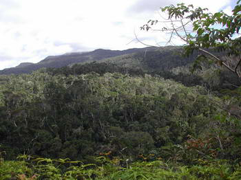
The humid forests are mainly localized in the oriental part of Madagascar, east of the waters dividing line. However the forest blocks relatively large are scattered on the central High Plateau and in the northern part of the island. The climate is tropical humid, characterized by abundant precipitations. From the north to the south; we meet numerous types of ecosystems representative of the humid forests of Madagascar: forests of transition, altimetry meadows, natural savanna and coral reefs. These ecosystems contain a unique biodiversity for which most of the animal and vegetal species are endemic. They belong either to a protected area or to a locality or region.
Six protected areas are already part of the World Heritage site in this ecoregion: the national parks of Marojejy, Masoala, Zahamena, Ranomafana, Andringitra and Andohahela. These protected areas are located on various reliefs. The altitude of the mountain chains exceeds 2000 m (massif of Marojejy and Andringitra, anosyenne chains). During the nomination of the natural parks in July 2007, the World Heritage Committee and the UICN have recommended the extension of the property.
Note: UNOFFICIAL TRANSLATION